非GEOコンステレーション解析ツールキット(NCAT) (Analysys Masonの年間サービス)
Non-GEO Constellations Analysis Toolkit (NCAT)
非GEOコンステレーション解析ツールキット5.3
非GEO衛星コンステレーション解析ツールキット(NCAT)は、低軌道(LEO)と中軌道(MEO)の衛星コンステレーションの客観的な評価を提供するために、厳密なデ... もっと見る

|

|
サマリー
非GEOコンステレーション解析ツールキット5.3
非GEO衛星コンステレーション解析ツールキット(NCAT)は、低軌道(LEO)と中軌道(MEO)の衛星コンステレーションの客観的な評価を提供するために、厳密なデータ駆動型解析と直感的なユーザーエクスペリエンスを組み合わせたものです。
NCATは、多様なデータセット、高度な分析、インタラクティブな視覚化、AI機能を統合することで、戦略家、ビジネスリーダー、技術専門家に、非静止型(非GEO)コンステレーションの能力と影響に関する信頼性の高い洞察を提供します。
NCATは、ユーザーフレンドリーなオンラインウェブアプリとして提供され、ユーザーは帯域幅の需給ダイナミクスをシームレスに調査し、市場アドレサビリティを評価し、ビジネスケースの感度を評価し、衛星データと打ち上げ統計を掘り下げることができます。このプラットフォームは、主要なパフォーマンス指標を自動的に計算し、衛星コンステレーションの競争力をベンチマークします。
ツールキット適用範囲
数万行のオリジナルコードと数百万件のクエリ可能なデータベースレコードによって駆動される18の統合ツールは、複数のレベルで星座のパフォーマンスを客観的かつデータ主導で評価します。何百万もの動的な計算は、設定可能なフィルター、視覚化コントロール、およびユーザー定義の入力を備えた直感的なインターフェイスを介して処理されます。すべての出力(データテーブル、チャート、ビジュアライゼーション)は、さらなる分析やレポート作成のために簡単にダウンロードできます。
特徴
-
厳密にコード化されたアルゴリズム 事実分析と視覚化を推進する。
-
包括的で定期的に更新されるデータベース。 これにより、ユーザーは最新のシミュレーションを実行できる。
-
毎日だ: 軌道上の衛星カウントと軌道観測は毎日自動的に更新される。
-
週刊誌だ:衛星カタログは毎週日曜日に自動的に更新される。
-
毎月だ:衛星と打上げの統計は毎月自動的に更新されます。
-
クォータリー: コア・ソフトウェアとデータベースの機能強化は、四半期ごとに展開される。
-
ポイント・アンド・クリックの双方向性。 ユーザーは、インタラクティブなマップやコントロール(レイヤー、フィルター、ボタン、設定など)を簡単に操作し、数回クリックするだけで、ズームインやズームアウト、ユーザー端末の位置設定、動的な計算やビジュアライゼーションを行うことができます。
-
マルチ軌道、マルチバンド解析。 シミュレーションは、1つまたは複数のシステムの軌道シェルの組み合わせで設定できるため、異なる周波数帯域にまたがる何千もの衛星の同時計算が可能です。
-
ダイナミックなアニメーションのビジュアライゼーション。 ユーザーは、衛星の位置、カバレッジ・フットプリント、可視衛星、アンテナのルックアングル、リンク遅延の変動、需給ヒートマップなど、主要な条件のリアルタイム伝搬を見ることができます。
-
時空間コントロール。 NCAT5は、グローバル、リージョナル、ローカルスケールのリアルタイム解析と加速タイムラプス解析の両方をサポートしている。 シミュレーションは最大300倍まで高速化でき、ユーザーは約5分で1日分のコンステレーション・パフォーマンスを分析できる。
-
六角形のグラウンドグリッド。 NCAT5は、国レベルの精度を持つダイナミックな六角形グリッドを採用しており、都市スケールの解像度(セル半径9km)まで設定可能です。Shapes'ツールにより、NCATデータベースにあらかじめ登録されている250以上の国や地域以外にも、カスタム地理エリアを定義することができます。
-
IPスループットの同時計算。 NCAT5は、ユーザーターミナルとゲートウェイのルックアングルの組み合わせを考慮しながら、すべてのユーザービームとゲートウェイビームで同時にリンクバジェットスループット解析を実行する。
-
柔軟な需要モデル。 このツールセットでは、ユーザーはあらかじめ設定された需要基準から選択したり、カスタムの需要パラメーター(ユーザー端末の分布や帯域幅需要の機能ドライバーを含む)を定義したりして、特定のユースケースに合わせたシミュレーションを行うことができます。
-
需要主導の供給。 NCATは、選択可能な公平性基準に基づいてステアラブルビームの容量をダイナミックに再構成し、変化する需要状況に実行可能な供給を最適に適合させるシミュレーションを行う。
-
モビリティ・ツール。 NCATは、ユーザー定義のスケジュールを通じて、幅広いモビリティ・アプリケーション(機内Wi-Fi、鉄道、海運、コネクテッドカーなど)をサポートする。さらにNCATは、何万ものルート、航空会社、空港をカバーするリアルタイムの商用フライトデータを統合し、機内接続(IFC)の需給ダイナミクスを評価します。
-
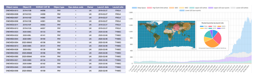
統計 NCAT5は、包括的なカタログ・データと衛星打ち上げ統計にアクセスして処理し、1957年以降に宇宙に打ち上げられた61,000以上の未分類天体のデータを検索するための設定可能なフィルタをユーザーに提供する。
-
レポート作成。 AIエージェントツールは、自然言語を使ってNCAT内部のツールやデータセットとシームレスに対話し、クエリへの回答、専門的なレポートの作成、シミュレーション結果の解釈を可能にする。
-
ダウンロード可能なチャートとデータ。 すべてのチャート、マップ、インフォグラフィックは、PDFまたはPNG形式でダウンロードできます。出力データは表形式の CSV 形式で入手でき、プラットフォーム外でのさらなる分析が可能です。ダウンロード可能なコンテンツには、表、チャートデータ、地図、ベンチマーク指標、タイムスタンプ付きサンプル、需給データ付き地上グリッド、評価サマリー、飛行ルート、ルックアングル統計、ビーム利用率などが含まれます。
アプリケーション
NCATは衛星通信(satcom)に重点を置いているが、地球観測(EO)と全地球航法衛星システム(GNSS)を評価する機能も含んでいる。
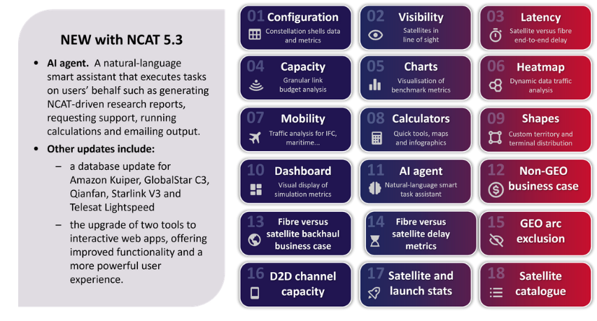
ツール
システムを多角的に分析し、ベンチマークするための18の設定可能なツール:
衛星の視認性と再訪問率
IPスループット、ビーム、衛星容量
帯域幅の需要と供給
D2Dチャネル容量
ビジネスケース感度
エンド・ツー・エンド遅延
打ち上げと衛星の統計。
コンステレーション・シェル
100以上の運用システム、計画システム、ファイリングシステムを含む(ユーザーによる編集および拡張が可能)
ゲートウェイ
370以上の調査済みゲートウェイ・ロケーション(ユーザーによる編集および拡張が可能)
地理的地域
250以上の国、地域、リージョン、サブリージョンが含まれる(ユーザーによる編集および拡張が可能)
質問に答える
-
現在および将来のNGSOアーキテクチャは、カバレッジ、容量、ビーム、衛星をどのようにベンチマークするのか?
-
ゲートウェイ、ユーザービーム、衛星ごとのフォワードおよびリターンリンク容量(スペクトラム、帯域幅、IPスループット)は?
-
国や地域ごとに、同時に何人のユーザーをサポートできるか?
-
使用可能な毎秒メガビットあたりの資本コストはどのように決められるのか?
-
宇宙船の製造コストや打ち上げコストに対するビジネスケースの感度は?
-
衛星通信コンステレーションが、十分なサービスを受けていない地域社会で光ファイバーを凌駕するのはどのような場合か?
-
バックホールの設備投資と固定資産税はビジネスケースにどう影響するか?
-
設定可能なサービスプランに基づいて、帯域幅の需給をどのように評価できるか、また、混雑のホットスポットはどこか。
-
異なる緯度と軌道シェルにおいて、視界に入る衛星の最大数、平均数、最小数は?
-
POP、光衛星間リンク(OISL)、リンク・リレーを考慮した場合、ファイバーの待ち時間はLEOシステムの待ち時間と比べてどうなのか?
-
非GEOシステムがGEO干渉を避けるための規制除外角度は?
このツールボックスを使うべき人
-
衛星事業者(GEO、非GEO、FSS、MSS/D2D)
-
宇宙船メーカーおよび部品ベンダー
-
地上/無線ネットワーク事業者(通信事業者、MNO、ISP、タワーコス、クラウドサービスプロバイダーなど)
-
地上システムベンダー(端末、アンテナ、ハブ/モデム、SD-WAN)
-
テレポート・オペレーター、衛星サービス・プロバイダー、GEOインテグレーター、非GEOインテグレーター
-
主要な非GEO容量ユーザー(政府、防衛関係者、航空会社、エネルギー会社など)
-
業界団体、研究所、機関
-
仮想コンステレーション・ソフトウェアを開発するIT企業
-
規制当局およびスペクトラム調査機関
-
金融機関および投資会社
衛星システムを含む(例)
Amazon Project Kuiper、AST SpaceMobile、Boeing、E-Space、G60 Thousand Sails (Qianfan)、Globalstar、Hughes、Inmarsat Orchestra、Intelsat MEO、Iridium、Kepler、Lynk Global、Mangata Networks、Omnispace、OneWeb、Rivada、SES mPOWER & O3b、SpaceX Starlink、Telesat Lighspeed、ViaSat
ページTOPに戻る
Summary
Non-GEO Constellations Analysis Toolkit 5.3
The Non-GEO Constellations Analysis Toolkit (NCAT) combines rigorous, data-driven analysis with an intuitive user experience to deliver objective assessments of low-Earth orbit (LEO) and medium-Earth orbit (MEO) satellite constellations.
NCAT equips strategists, business leaders and technical professionals with reliable insights into the capabilities and impact of non-geostationary (non-GEO) constellations by integrating diverse datasets, advanced analytics, interactive visualisations and AI capabilities.
NCAT is delivered as a user-friendly online web app, and empowers users to seamlessly explore bandwidth supply and demand dynamics, assess market addressability, evaluate business case sensitivities and delve into satellite data and launch statistics. The platform automatically calculates key performance metrics and benchmarks the competitiveness of satellite constellations (both against each other and relative to terrestrial networks), all without requiring deep technical expertise.
Toolkit coverage
18 integrated tools, driven by tens of thousands of lines of original code and millions of queryable database records, provide objective, data-driven assessments of constellation performance at multiple levels. Millions of dynamic calculations are processed via an intuitive interface with configurable filters, visualisation controls and user-defined inputs. All outputs (data tables, charts and visualisations) are easily downloadable for further analysis or reporting.
Features included
-
Rigorously coded algorithms that drive factual analytics and visualisations.
-
A comprehensive, regularly updated database. This enables users to run up-to-date simulations.
-
Daily: in-orbit satellite counts and orbital observations are updated automatically every day.
-
Weekly: the satellite catalogue is updated automatically each Sunday.
-
Monthly: satellite and launch statistics are refreshed automatically every month.
-
quarterly: core software and database enhancements are deployed every quarter.
-
Point-and-click interactivity. Users can easily navigate interactive maps and controls (such as layers, filters, buttons and settings) to zoom in and out, set user terminal locations and drive dynamic calculations and visualisations with just a few clicks.
-
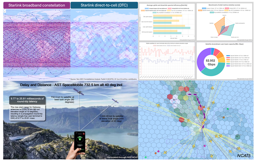
Multi-orbit, multi-band analysis. Simulations can be configured across combinations of orbital shells from one or multiple systems, thus enabling concurrent calculations for thousands of satellites across different frequency bands.
-
Dynamic, animated visualisations. Users can view real-time propagation of key conditions, including satellite positions, coverage footprints, visible satellites, antenna look angles, link latency variations and supply–demand heatmaps.
-
Space-time controls. NCAT5 supports both real-time and accelerated time-lapse analysis at global, regional or local scales. Simulations can be sped up by up to 300×, enabling users to analyse a full day of constellation performance in around 5 minutes.
-
Hexagonal ground grid. NCAT5 employs a dynamic hexagonal grid with country-level precision, configurable down to city-scale resolution (~9 km cell radius). The ‘Shapes’ tool enables users to define custom geographical areas beyond the 250+ countries and regions preloaded in the NCAT database.
-
Concurrent IP throughput computations. NCAT5 performs concurrent link-budget throughput analysis across all user and gateway beams, accounting for combinations of user-terminal and gateway look angles.
-
Flexible demand models. The toolset enables users to choose from pre-set demand criteria or define custom demand parameters (including user terminal distribution and functional drivers of bandwidth demand) to tailor simulations to specific use cases.
-
Demand-driven supply. NCAT simulates dynamic reconfigurations of steerable beam capacity based on selectable fairness criteria to optimally match feasible supply with changing demand conditions.
-
Mobility tool. NCAT supports a wide range of mobility applications (such as in-flight Wi-Fi, rail, maritime and connected vehicles) through user-defined schedules. Additionally, NCAT integrates real-time commercial flight data, covering tens of thousands of routes, airlines and airports, to assess in-flight connectivity (IFC) supply and demand dynamics.
-
Statistics. NCAT5 accesses and processes comprehensive catalogued data and satellite launch statistics, presenting users with configurable filters to explore data for over 61 000 unclassified objects launched into space since 1957.
-
Report generation. The AI Agent tool uses natural language to interact seamlessly with internal NCAT tools and datasets, enabling it to answer queries, generate professional reports and interpret simulation results.
-
Downloadable charts and data. All charts, maps and infographics can be downloaded in PDF or PNG format. Output data is available in tabular CSV format, enabling further analysis outside the platform. Downloadable content includes tables, chart data, maps, benchmark metrics, time-stamped samples, terrestrial grids with supply and demand data, assessment summaries, flight routes, look angle statistics, beam utilisation and more.
Applications
NCAT is focused on satellite communications (satcom) but includes features to assess Earth observation (EO) and global navigation satellite systems (GNSS).
Tools
18 configurable tools to analyse and benchmark systems from multiple angles, including:
satellite visibility and revisit rates
IP throughput, beam and satellite capacity
bandwidth supply and demand
direct-to-device (D2D) channel capacity
business case sensitivity
end-to-end latency
launch and satellite statistics.
Constellation shells
100+ operational, planned and filed systems included (user editable and expandable)
Gateways
370+ surveyed gateway locations (user editable and expandable)
Geographical regions
250+ countries, territories, regions and subregions included (user editable and expandable)
Questions answered
-
How do current and future NGSO architectures benchmark across coverage, capacity, beam, and satellites?
-
What is the forward and return link capacity (spectrum, bandwidth and IP throughput) per gateway, user beam and satellite?
-
How many users can constellations support simultaneously, by country or territory?
-
How can the capital cost per usable megabits per second be determined?
-
What is the business-case sensitivity to spacecraft manufacturing and launch costs?
-
When can satcom constellations outperform fibre-optics in underserved communities?
-
How does backhaul capex and opex affect the business case?
-
How can bandwidth supply and demand be assessed, based on configurable service plans, and where are the congestion hotspots?
-
What is the maximum, average and minimum number of satellites in view or line of sight at different latitudes and orbital shells?
-
How does fibre latency compare with that of LEO systems, factoring in POPs, optical inter-satellite links (OISLs) and link relays?
-
What are the regulatory exclusion angles for non-GEO systems to avoid GEO interference?
Who should use this toolbox
-
Satellite operators (GEO, non-GEO, FSS and MSS/D2D)
-
Spacecraft manufacturers and component vendors
-
Terrestrial/wireless network operators (telecoms operators, MNOs, ISPs, towercos, cloud services providers and so on)
-
Ground system vendors (terminals, antennas, hub/modems and SD-WAN)
-
Teleport operators, satellite service providers and GEO–non-GEO integrators
-
Major non-GEO capacity users (such as governments, defence players, airlines and energy companies)
-
Industry associations, research labs and institutions
-
IT companies developing virtualised constellation software
-
Regulators and spectrum research agencies
-
Financial institutions and investment firms
Satellite systems included (examples)
Amazon Project Kuiper, AST SpaceMobile, Boeing, E-Space, G60 Thousand Sails (Qianfan), Globalstar, Hughes, Inmarsat Orchestra, Intelsat MEO, Iridium, Kepler, Lynk Global, Mangata Networks, Omnispace, OneWeb, Rivada, SES mPOWER & O3b, SpaceX Starlink, Telesat Lighspeed, ViaSat
ページTOPに戻る
本サブスクリプションと同分野(ネットワーク)の最新刊サブスクリプション
Analysys Mason社の 宇宙分野 での最新刊サブスクリプション
本サブスクリプションと同じKEY WORD()の最新刊サブスクリプション
- 本サブスクリプションと同じKEY WORDの最新刊サブスクリプションはありません。
よくあるご質問
Analysys Mason社はどのような調査会社ですか?
Analysys Mason (アナリシスメイソン)は、英国に本社をおく通信市場全般を対象とする調査会社で、ネットワーク技術や通信用ソフトウェアなど、幅広い通信市場に関する調査レポートの出版やカスタム... もっと見る
調査レポートの納品までの日数はどの程度ですか?
在庫のあるものは速納となりますが、平均的には 3-4日と見て下さい。
但し、一部の調査レポートでは、発注を受けた段階で内容更新をして納品をする場合もあります。
発注をする前のお問合せをお願いします。
注文の手続きはどのようになっていますか?
1)お客様からの御問い合わせをいただきます。
2)見積書やサンプルの提示をいたします。
3)お客様指定、もしくは弊社の発注書をメール添付にて発送してください。
4)データリソース社からレポート発行元の調査会社へ納品手配します。
5) 調査会社からお客様へ納品されます。最近は、pdfにてのメール納品が大半です。
お支払方法の方法はどのようになっていますか?
納品と同時にデータリソース社よりお客様へ請求書(必要に応じて納品書も)を発送いたします。
お客様よりデータリソース社へ(通常は円払い)の御振り込みをお願いします。
請求書は、納品日の日付で発行しますので、翌月最終営業日までの当社指定口座への振込みをお願いします。振込み手数料は御社負担にてお願いします。
お客様の御支払い条件が60日以上の場合は御相談ください。
尚、初めてのお取引先や個人の場合、前払いをお願いすることもあります。ご了承のほど、お願いします。
データリソース社はどのような会社ですか?
当社は、世界各国の主要調査会社・レポート出版社と提携し、世界各国の市場調査レポートや技術動向レポートなどを日本国内の企業・公官庁及び教育研究機関に提供しております。
世界各国の「市場・技術・法規制などの」実情を調査・収集される時には、データリソース社にご相談ください。
お客様の御要望にあったデータや情報を抽出する為のレポート紹介や調査のアドバイスも致します。
|
|